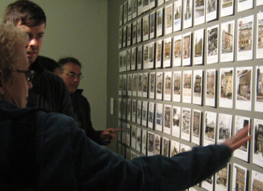
ERA’s exhibit down at the Harbourfront Centre received some attention recently in the National Post, a mention on Spacing’s blog by Heritage Toronto’s Gary Miedema, and on the blog Her*itage and His*tory. We thought it would be a good time to give readers of the ERA Office Blog a little more background on the exhibit and show off some photos.

One one side of the gallery space are photos captured this winter (shown above) of buildings that existed in 1858 and are still standing today. All the photos show an address and accompanying a number of them is information on who owned and used the building in 1858. On the opposite side of the space is a detailed wall-to-wall map of Toronto, circa 1858, which indicates every building in existence at the time. Each photo has a corresponding pin that is located on the 1858 map (shown below). On the window wall are excerpts from Brown’s Toronto General Directory 1856 that describes the state of the city in that year through statistics and various data. The historic usage and ownership of many of the buildings were found in this directory.


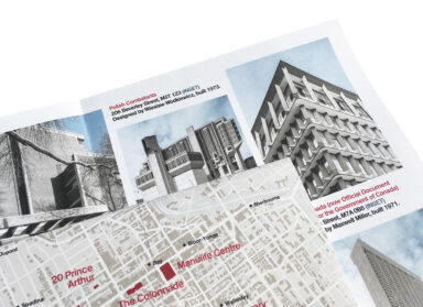
The choice to use a map from 1858 is not random. The maps, officially known as the Boulton Atlas of Toronto, were produced by brother William Sommerville Boulton and Henry Carew Boulton, and published by John Ellis. Derek Hayes, editor of the Historical Atlas of Toronto ( Douglas & McIntyre, 2008) says the map is historically significant because “it shows the existence or otherwise of actual buildings in the city, rather than just subdivided lots.” Each building type is categorized by colour: red properties are made of brick, grey properties that are hatched are stone and, grey properties that are solid are wood framed buildings. At the time, almost 80% of all Toronto buildings were constructed of wood.

If you get a chance to visit, you’ll find yourself pacing back and forth between these walls locating photos of interest on the map. But since the map is from 1858, things have changed and places and roads that you know exist today (like the intersection of Yonge and Dundas) did not exist back then. You can also discover Dundas Street has a section that runs north-south on what is now Denison Avenue. Dundas then appears again, for only a few blocks, going east-west between Bathurst and Hope (what is now Claremont) streets.
You might also discover certain urban anomalies, such as how modern-day University Avenue (known as College Avenue in 1858) is actually the combination of two previous streets: one side of the street was owned by the University of Toronto and the other side was owned by the City.


Top photo by Tom Bilenkey, all other photos by Matthew Blackett